The DC Metro Map is a handy guide for travelers who want to explore the city and its suburbs by rail.
Modifications: adjusted line colors, updated station icons,
and added new stations opened after the original map. For the official metro map please visit the WMATA website
A Guide to the Washington DC Metro System
If you are planning to visit or live in Washington DC, you might want to learn how to use the metro system. The metro is one of the busiest public transportation systems in the country, serving more than 600,000 customers a day. It connects all four quadrants of DC with suburban Virginia and Maryland, both inside and outside the Capital Beltway³. In this blog post, we will give you an overview of the metro map, the dc metro lines, and some history of the metro system. Also, explore our Discover DC guide for a list of venues and their nearest Metro stations to help you explore the city by train.
Washington Metropolitan Area Transit Authority – MetroAlerts Washington Metropolitan Area Transit Authority – MetroAlerts RSS Feeds
- Feed has no items.
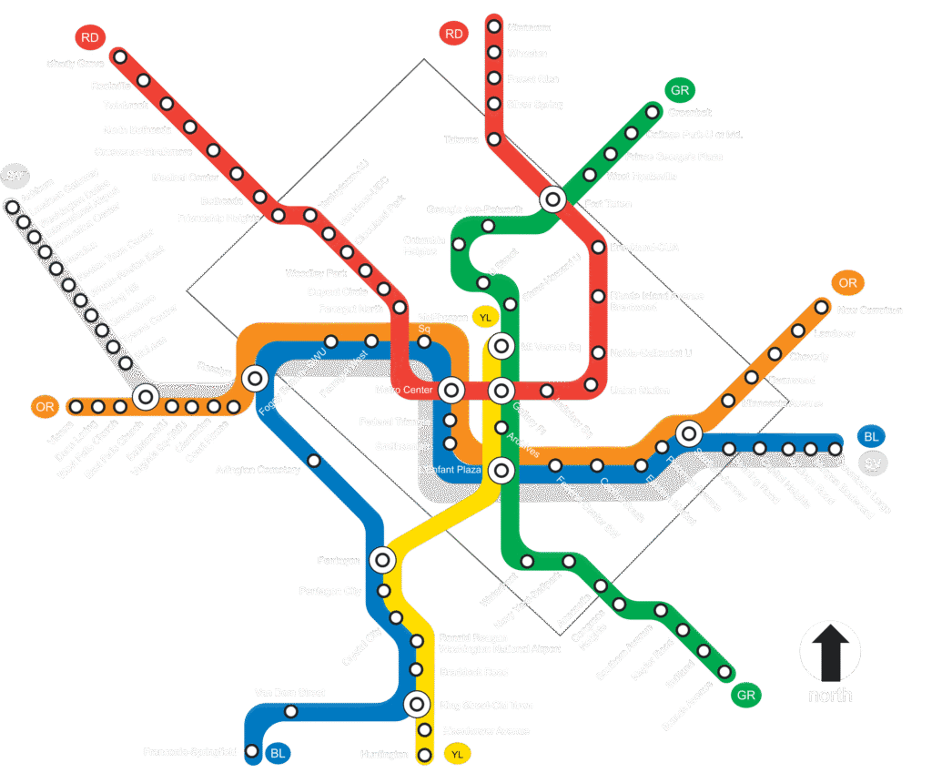
Metro Map DC
The metro map dc is a schematic diagram that shows the six color-coded rail lines and the 97 stations of the metro system. You can find a printable version of the map on the official website of the Washington Metropolitan Area Transit Authority (WMATA), which operates the metro system. You can also use their online trip planner or mobile app to plan your route and check fares, schedules, and alerts.
The DC metro map is designed to help you find your way around the system easily. Here are some tips on how to read the map:
- The map shows the direction of travel for each line with arrows at the end of each line. For example, the Red Line runs from Shady Grove to Glenmont, and vice versa.
- The map shows transfer stations where you can change from one line to another with a black circle. For example, you can transfer from the Red Line to the Green Line at Gallery Place-Chinatown station.
- The map shows stations that are served by more than one line with a white dot. For example, L’Enfant Plaza station is served by the Orange, Silver, Blue, Yellow, and Green Lines.
- The map shows stations that are close to each other with a thin black line. For example, Metro Center station is connected to Gallery Place-Chinatown station by a pedestrian tunnel.
- The map shows stations that are outside the Capital Beltway with a dashed line. For example, Vienna station is outside the Beltway on the Orange Line.
Metro Lines
The metro system has six color-coded rail lines: Red, Orange, Silver, Blue, Yellow, and Green². Each line has its own characteristics and serves different areas of DC and its suburbs. Here is a brief description of each line:
- The Red Line with 27 stations is the oldest and longest line in the system. It runs from Shady Grove in Maryland to Glenmont in Maryland, passing through downtown DC and serving landmarks such as Union Station, Dupont Circle, and Woodley Park-Zoo/Adams Morgan.
- The Orange Line with 26 stations runs from Vienna in Virginia to New Carrollton in Maryland, passing through downtown DC and serving landmarks such as Smithsonian, Capitol South, and Eastern Market.
- The Silver Line with 28 stations is the newest line in the system. It runs from Wiehle-Reston East in Virginia to Largo Town Center in Maryland, passing through downtown DC and serving landmarks such as McPherson Square, Foggy Bottom-GWU, and Smithsonian. It shares most of its route with the Orange and Blue Lines but branches off at East Falls Church station in Virginia and Stadium-Armory station in DC.
- The Blue Line with 27 stations runs from Franconia-Springfield in Virginia to Largo Town Center in Maryland, passing through downtown DC and serving landmarks such as Pentagon City, Arlington Cemetery, and Federal Triangle. It shares most of its route with the Orange and Silver Lines but branches off at Rosslyn station in Virginia and Stadium-Armory station in DC.
- The Yellow Line with 21 stations runs from Huntington in Virginia to Greenbelt in Maryland, passing through downtown DC and serving landmarks such as Reagan National Airport, L’Enfant Plaza, and U Street/African-Amer Civil War Memorial/Cardozo. It shares most of its route with the Green Line but branches off at King Street-Old Town station in Virginia and Mount Vernon Square station in DC.
- The Green Line with 21 stations runs from Branch Avenue in Maryland to Greenbelt in Maryland, passing through downtown DC and serving landmarks such as Navy Yard-Ballpark, Waterfront, and Columbia Heights. It shares most of its route with the Yellow Line but branches off at Fort Totten station in DC.
Metro History
The metro system was conceived in the 1950s as a way to alleviate traffic congestion and improve mobility in the region. The first segment of the system opened in 1976 with five stations on the Red Line. Since then, the system has expanded gradually with new lines, extensions, and stations over the years.
Some of the major milestones in metro history include:
- In 1977, the Blue Line opened with nine stations between National Airport (now Reagan National Airport) and Stadium-Armory.
- In 1978, the Orange Line opened with seven stations between Ballston-MU (now Ballston) and New Carrollton.
- In 1983, the Yellow Line opened with five stations between Gallery Place-Chinatown (now Gallery Place) and National Airport (now Reagan National Airport)⁴.
- In 1991, the Green Line opened with five stations between U Street/African-Amer Civil War Memorial/Cardozo (now U Street) and Anacostia.
- In 2001, the Red Line was extended from Grosvenor-Strathmore (now Grosvenor) to Shady Grove.
- In 2004, the Blue Line was extended from Addison Road-Seat Pleasant (now Addison Road) to Largo Town Center.
- In 2006, the Yellow Line was extended from Mount Vernon Square/7th St-Convention Center (now Mount Vernon Square) to Fort Totten.
- In 2014, the Silver Line opened with five stations between East Falls Church and Wiehle-Reston East.
- In 2021, six new stations were added to the Silver Line between Wiehle-Reston East and Ashburn.
The metro system is still evolving as new projects are underway or planned for future development.
Conclusion
The metro system is an essential part of Washington DC’s transportation network. It offers an efficient, convenient, and affordable way to travel around the city and its suburbs. By using this guide, you can learn how to navigate the metro map dc , explore different metro lines ,and discover some history of this remarkable engineering feat.
We hope you enjoyed this blog post about metro map dc . If you did , please share it with your friends or leave us a comment below . And if you want more information about Washington DC , check out these other relevant websites :
Home | WMATA – The official website of WMATA , where you can find everything you need to know about using metro services .
Navigating Washington , DC’s Metro System | Metro Map & More – A helpful guide by Destination DC , where you can find tips , tricks ,and fun facts about riding metro .
List of Washington Metro Stations – Wikipedia – A comprehensive list by Wikipedia , where you can find detailed information about each metro station .