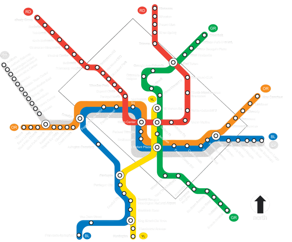
Whether you’re a first-time visitor here in Washington DC or a seasoned commuter, this page provides a detailed look at each of the six color-coded lines, their stations, a glimpse into their history, and some helpful tips for your journey.
For the full visual overview check out the DC Metro Map (printable & mobile-friendly).
Quick links

Modifications: adjusted line colors, updated station icons, and added new stations opened after the original map. For the official metro map please visit the WMATA website
Red Line
Shady Grove ⇄ Glenmont
Stations (27)
- Shady Grove
- Rockville
- Twinbrook
- North Bethesda
- Grosvenor–Strathmore
- Medical Center
- Bethesda
- Friendship Heights
- Tenleytown–AU
- Van Ness–UDC
- Cleveland Park
- Woodley Park
- Dupont Circle
- Farragut North
- Metro Center
- Gallery Place–Chinatown
- Judiciary Square
- Union Station
- NoMa–Gallaudet U
- Rhode Island Ave–Brentwood
- Brookland–CUA
- Fort Totten
- Takoma
- Silver Spring
- Forest Glen
- Wheaton
- Glenmont
Good to know & quick history: The Red Line was Metro’s 1976 starter route and is still the busiest.
It’s the only line that never shares track, forming a big “U” through downtown.
Trains run every 6 min off-peak and every 5 min in rush.
Key transfers: Metro Center (to Blue/Orange/Silver) and Fort Totten (to Green). See the DC Metro map for platform layouts.
Blue Line
Franconia-Springfield ⇄ Downtown Largo
Stations (28)
- Franconia–Springfield
- Van Dorn Street
- Eisenhower Avenue
- King St–Old Town
- Braddock Road
- Potomac Yard–VT
- Ronald Reagan Washington National Airport
- Crystal City
- Pentagon City
- Pentagon
- Arlington Cemetery
- Rosslyn
- Foggy Bottom–GWU
- Farragut West
- McPherson Square
- Metro Center
- Federal Triangle
- Smithsonian
- L’Enfant Plaza
- Federal Center SW
- Capitol South
- Eastern Market
- Potomac Avenue
- Stadium–Armory
- Benning Road
- Capitol Heights
- Addison Road–Seat Pleasant
- Morgan Boulevard
- Largo Town Center
Snapshot: Opened in 1977, the Blue Line links Alexandria, the National Mall and eastern Prince George’s County.
It crosses the Potomac via the lower level of the 14th-Street Bridge and is the only line that serves Arlington Cemetery.
Expect 10–12 min headways off-peak.
Check our Metro map DC for live alerts before riding.
Orange Line
Vienna ⇄ New Carrollton
Stations (26)
- Vienna/Fairfax–GMU
- Dunn Loring
- West Falls Church
- East Falls Church
- Ballston–MU
- Virginia Square–GMU
- Clarendon
- Court House
- Rosslyn
- Foggy Bottom–GWU
- Farragut West
- McPherson Square
- Metro Center
- Federal Triangle
- Smithsonian
- L’Enfant Plaza
- Federal Center SW
- Capitol South
- Eastern Market
- Potomac Avenue
- Stadium–Armory
- Minnesota Avenue
- Deanwood
- Cheverly
- Landover
- New Carrollton
Need-to-know: Debuted in 1978, the Orange follows I-66 in Virginia and dives under the National Mall.
It shares 13 stations with the Blue Line and 18 with the Silver Line.
Frequency: every 10 min weekdays / 12 min weekends.
Use Rosslyn for quick cross-platform transfers. Full metro map for trip-planning.
Silver Line
Ashburn ⇄ Downtown Largo
Stations (34)
- Ashburn
- Loudoun Gateway
- Dulles International Airport
- Innovation Center
- Herndon
- Reston Town Center
- Wiehle–Reston East
- Spring Hill
- Greensboro
- Tysons
- McLean
- East Falls Church
- Ballston–MU
- Virginia Square–GMU
- Clarendon
- Court House
- Rosslyn
- Foggy Bottom–GWU
- Farragut West
- McPherson Square
- Metro Center
- Federal Triangle
- Smithsonian
- L’Enfant Plaza
- Federal Center SW
- Capitol South
- Eastern Market
- Potomac Avenue
- Stadium–Armory
- Benning Road
- Capitol Heights
- Addison Road–Seat Pleasant
- Morgan Boulevard
- Largo Town Center
Quick facts: Phase I (2014) reached Wiehle; Phase II (2022) pushed the line 11 mi to Dulles Airport and Ashburn, making Silver the longest route at 41 mi.
Expect 10-12 min headways—slower off-peak beyond Wiehle.
Tysons’ four stations put every mall entrance within a 10-min walk.
Full metro map DC shows exits and parking.
Yellow Line
Huntington ⇄ Mount Vernon Sq 7th St-Convention Center (Rush Hour: Fort Totten)
Stations (13, extends to 20 in rush hour)
- Huntington
- Eisenhower Avenue
- King St–Old Town
- Braddock Road
- Potomac Yard–VT
- Ronald Reagan Washington National Airport
- Crystal City
- Pentagon City
- Pentagon
- L’Enfant Plaza
- Archives–Navy Memorial–Penn Quarter
- Gallery Place–Chinatown
- Mount Vernon Square/7th St–Convention Center
Heads-up: After the 2023 bridge rebuild, Yellow terminates at Mount Vernon Sq.
It’s still the fastest Pentagon⇄Downtown ride: 4 stops in ~11 min.
Trains every 8–12 min weekdays; 15 min weekends.
Check our DC metro map for future Greenbelt service proposals. [oai_citation:0‡Wikipedia](https://en.wikipedia.org/wiki/Yellow_Line_%28Washington_Metro%29?utm_source=chatgpt.com)
Green Line
Branch Avenue ⇄ Greenbelt
Stations (21)
- Branch Avenue
- Suitland
- Naylor Road
- Southern Avenue
- Congress Heights
- Anacostia
- Navy Yard–Ballpark
- Waterfront
- L’Enfant Plaza
- Archives–Navy Memorial–Penn Quarter
- Gallery Place–Chinatown
- Mount Vernon Square/7th St–Convention Center
- Shaw–Howard University
- U Street/African-Amer Civil War Memorial/Cardozo
- Columbia Heights
- Georgia Ave–Petworth
- Fort Totten
- West Hyattsville
- Prince George’s Plaza
- College Park–University of Maryland
- Greenbelt
Overview: The final piece of the original network, the Green Line opened in stages from 1991 to 2001 and now stretches 23 mi.
It’s the only line that stays entirely within DC & Maryland, linking Nationals Park, the Wharf, U-Street nightlife and College Park.
Standard headway is 8 min peak / 12 min off-peak.
Grab our printable metro map to see transfer shortcuts.
Planning more than one trip? Jump back to the DC Metro map.